It irks me to not immediately fall asleep after a long day at the wheel. I used my final waking hours to get a look at Friday’s possible setup. I wanted to go to south central Kansas, around Medicine Lodge. It is a relatively large village in the area, the site of a treaty signed and misplaced a long time ago. I had taken the first room I could find because I did not want to listen to my car, the Cubs, Giants, or Royals another second. In my quest for excellence in photography and science, I have spent more nights on Wyatt Earp Boulevard than on Bourbon Street and while the smells could not be more dissimilar the rates are more or less the same. Due to the dominant feedlot industry, it is an ill wind that blows from just about every direction, so I opt for the hermetically-sealed rooms, preferably smoking. Turn the volume on the fan up, for good measure. At least there were no bedbugs that I could locate. I’m talking to you, Norway.
I slept in for the first time on the trip because I was close to my target area. Breakfast was Fruit Loops, gravy on the side. The satellite loop showed that my target area was buried in thick cirrus, which required a fresh paradigm. Cirrus is bad news because it causes downward motion in the atmosphere and reduces the heat at the surface. It can drive one to gravy. I spent three hours after breakfast packing the car, looking at the data as it came in, and trying to figure out how this situation would work out.
SPC kept the faith, maybe from inertia; enhanced risk, increasing moisture, adequate winds, and so forth. I put my faith in the satellite loop, which showed clear skies spreading into northern Kansas, and the surface observations that showed Gulf moisture oozing into central Kansas. The low level winds would be favorable for rotating storms. I left town at 11am for Great Bend, but slowly. This aggravated some of my fellow motorists since I was only ten miles/hour above the posted limit. Low-level moisture was abundant, even to the naked eye. There were scattered cumulus clouds all over the area. I was where I would want to be if I was not there, if you know what I mean. And I would have good data via the internet for this chase.
Larned had a few fast food places so I stopped for lunch and a break from the car. The storm-monger crowd had focused on northern Texas so I felt a little left out on the discussion boards. The high-resolution models consistently showed initiation by 3pm, north of Dodge City. These storms would become clusters and lines as they moved eastward to the eastern part of the state. Considering the state of numerical weather prediction when I got into this business, the progress is remarkable. But if the models were perfect we would print them in the daily paper and I could stay home. I should probably back off from the computer but I cannot look away. Mediocre thunderstorms composed a Poissonesque radarscape over far western Kansas during the early afternoon. These storms were not severe, but were a good indication that the new activity would form soon in the better airmass.
The best moisture curved from south central Kansas to the northwest, through Great Bend, toward some obscure coordinate east of Hill City. I watched the atmosphere, which hates us, evolve from the Santa Fe Trail Museum near Larned. There were developing storms to my south, around St. John, and a severe storm way out west near Goodland. I gave the southern cells a fair chance to develop, which they did not, and then headed north toward the interstate.
The storms started almost overhead around 2:30pm. A good forecast; the growing towers were beautiful bright white against unusually blue sky. I forgot to mention that my xmradio died. The storms would get my head back in the game, but it meant no static-free baseball, no new music, but no White Sox-tainted version of the Royals game. I would be alone. With my dark thoughts.
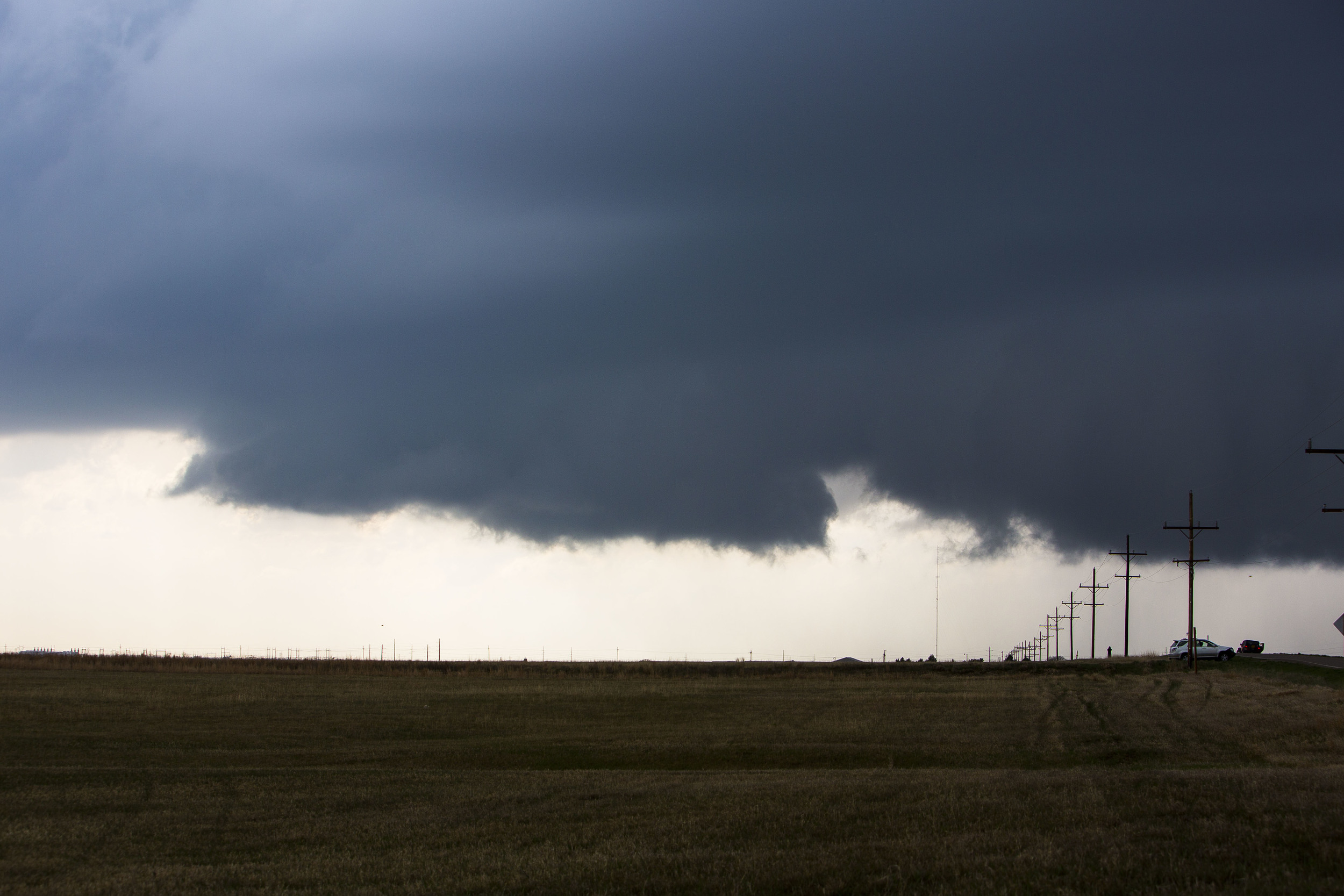
Anyway, the cells formed in a north-ish/south-ish line between Wakeeney and Hays. About this time, SPC issued the tornado watch and a half-hour later the first severe warning came out for Ellis County. I set up my camera for time-lapse north of Hays and recorded tornadogenesis failure. Shame, since it really had great character for almost 30 minutes. Another flank had developed to the northeast so I stopped shooting and took off for the new updraft. I saw a brief but substantial cone tornado at 5pm from this part of the storm. There was no place to pull off the road for a picture due to the local chasers in their pickups. There was a brief touchdown prior to this, and numerous reports afterward. From my perspective, the thing was wrapped in rain and life would be hard.
I continued east, listening to a local Hays fm station. Law enforcement reported one or two brief touchdowns in rain. I thought the best picture opportunities were over with the thing shrouded in precipitation. That did not stop me and thousands of others from following the thing as it very slowly moved into northeastern Ellis County. Reed Timmer’s Dominator rumbled up behind me. He has installed a row of painful high-intensity LED lights on the front for a retro-Cylon look. Fortunately the Four Cylinders of the Apocalypse is equipped with an adjustable rear-view mirror. The storm looked absolutely wonderful on radar and the tornado warning for the cell was re-issued repeatedly for over an hour. I got a few pictures of the overall storm. The roads made it even less likely that a solo chaser would manage any decent tornado photography.

Once the storm finally made it into Lincoln County, to the east of Ellis, the fm station declared the storm to no longer be a threat. In your face, Lincoln County. Maybe there is bad blood between the two that goes back a couple of centuries. Anyway, Lincoln County enjoyed warnings for awhile as the storm showed no sign of being in a hurry.
I surveyed the radar for another storm with a better road network. There was a stationary cell out in Gove County, but I would have to punch through a severe line to get there, and it was already past sunset. Lightning would be nice but with my luck this year I would let that unfold on the way to Wichita rather than park and stare. It didn’t.
The Kansas tornadoes ended around 6:30, then Texas, Louisiana, and Mississippi lit up with reports through early Saturday morning. I had a decent three days with excellent storms. I made good time back to Memphis on Saturday, and discovered that the new bait shop was ready.
